|
The
Brentwood neighborhood in Phoenix, AZ is comprised of 177
households with a median household income of $40,159.
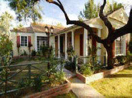
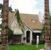
Tudors and Bungalows dominate this quaint
historic district.
Tons of original features are prominent in these homes such as
original doorknobs, hardwood floors, original, colored ceramic
tile in the bathrooms and kitchens and built-ins of all designs. The architecture is classic with coved ceilings and wide
archways creating a dramatic, elegant and cozy atmosphere.
Historical Development: Phoenix and the
Brentwood Neighborhood
Early
Phoenix: Late 1800's to 1920
Increasing
population and growth of the agricultural sector in the
Salt River Valley in the late 1800's necessitated the
establishment of a town site for Phoenix. The town site
finally chosen in 1870 was an unoccupied area in the
north half of Section 8, T1N, R3E (Luckingham 1989);
this area did not include the Brentwood neighborhood,
which was northeast of the city’s original town site. In
1889, the territorial capital was moved from Prescott to
Phoenix (Lykes 1993), thus ensuring the future of the
fledgling town.
Access to and from the town
remained difficult until the arrival of the Maricopa and
Phoenix Railroad (M&P) in 1887. With the arrival of the
railroad, the residents of early Phoenix became
connected to the outside world in terms of commerce,
industry and population movement (Luckingham 1989). The
addition of the Santa Fe, Prescott and Phoenix Railroad
(SFP&P) in 1895 connected Phoenix to the northern
transcontinental route (Jackman et al. 1999). As a
result, Phoenix became the transportation hub of the
Arizona Territory.
Passage of the National
Reclamation Act of 1902 sought to better utilize water
resources through large-scale irrigation projects from
water stored behind massive dams (Zarbin 1986, 1997).
Construction of the Roosevelt Dam at the confluence of
the Salt River and Tonto Creek began in 1906 and the dam
was in operation by 1911 (Luckingham 1989). The economic
and demographic importance of Roosevelt Dam for Phoenix
was significant (City of Phoenix 1994). The city’s
population increased and the business/agricultural
sector expanded as a result of a dependable water supply
and electrical power (Luckingham 1989). Promotional
campaigns by local civic leaders helped double the
population of Phoenix between 1900 and 1910 (Luckingham
1989), from 5,500 to 11,134, followed by a doubling
again to 29,053 by 1920 (Lykes 1993). By 1913, Phoenix
had grown to encompass 3.2 square miles, but did not yet
include the future Brentwood neighborhood.
Prosperity, Economic Collapse and Recovery:
1920-1941
Expansion of the city was
necessary to cope with the influx of residents as a
result of the successful city booster campaigns and the
economic prosperity of the 1920's. Transportation played
a prominent role. The street railway system was first
developed by Moses Sherman in 1887 and used a
horse-drawn car for transportation. The growth of the
Phoenix Street Railway Company was rapid as the trolleys
were converted to electrical use in 1893 (Luckingham
1989). Promoters of real estate development used the
streetcar routes to make their developments more
attractive to buyers. Often, property owners had to
share in the costs of extending railway lines through
their neighborhoods. The Brill Line, closest to the
future Brentwood
Historic District,
ran north/south along 10th Street between Pierce and
Brill Streets, and was extended further to the north in
1913 (Hackbarth 1995).
Transportation
improvements around the state played a key role in the
growth of Phoenix. The Federal Aid Road Act of 1916 and
its successor, the Federal Highway Act of 1921, inspired
a decade-long era of intensive highway construction and
improvements to existing roadways in Arizona. Federal,
state and county highway improvements transformed
Phoenix into a major highway transportation center
between El Paso and Los Angeles, which complemented the
role and expansion of the railroads at the same time.
The city’s role as a transportation hub across the
southwestern deserts, coupled with its own internal
growth as an agricultural, business and mining center,
propelled rapid population growth. Between 1920 and
1930, the city’s population grew from 29,053 to 48,118
(Lykes 1993), which in turn fueled a boom in the housing
market. New subdivisions were springing up in all
directions surrounding the city’s core. Between 1925 and
1927, 84 subdivisions were platted (Janus Associates,
Inc. 1989).
The Brentwood area was an early
beneficiary of this explosive growth; the first
subdivision, McDowell Heights, was platted in 1924,
followed by Brentwood and East Brentwood in 1928.
Together, these three subdivisions represented a roughly
four-by-four block addition to the city, with over 100
lots available to middle-income residents. Rural areas
outside the Phoenix city limits were listed in the
directory by mail route number; formal addresses for the
immediate area surrounding the Brentwood Historic
District would not appear in the city directories until
about 1926. A large portion of this new neighborhood
also sat atop an extensive prehistoric site, first
identified as La Ciudad de Los Pueblitos by the Hemenway
Southwest Archaeological Expedition of 1887-1888 (Zablon
1981). The prehistoric site was occupied between AD 700
and 1050 and was investigated as part of the Interstate
10 inner-loop construction project (Wilcox 1987; Zablon
1981). Currently, there are no known surface or open
exposures of this important site in the Brentwood
Historic District, but any future earth-moving
activities may have the potential to impact buried
cultural deposits.
The Great Depression
and New Deal in Phoenix: 1932-1941
The
devastating economic impact of Black Friday and the
following Great Depression was slow to affect Phoenix.
However, when copper values plummeted from $155.7
million in 1929 to $14.7 million in 1932, mines were
shut down and workers were left jobless. Several banks
in the Valley shut down, causing a cycle of lost
business, sales and jobs. The effects of the Depression
on the building industry was most evident between 1932
and 1936 (Luckingham 1989), but the effect on the
housing industry occurred much earlier. In 1929, for
example, over 900 homes were constructed in Phoenix; the
following year, only 209 were constructed (Kotlanger
1983).
By 1932, the entire construction industry
nearly came to a halt as a combination of job loss and
unemployment, lack of business and lending capital, and
shrinkage of the Phoenix economy made little demand for
new housing. The last flash of housing construction in
the pre-1938 Brentwood neighborhood occurred in
1930-1931 with only a few houses appearing in 1934 and
1935. Three new houses were built between 1938 and 1939,
all in the newly platted Wright Davis subdivision.
However, as the effects of the Great Depression waned in
the late 1930's and the country geared up for possible
war, housing construction in the Brentwood neighborhood
was renewed, tentatively at first in the 1940's, then
boomed once again throughout the war years.
The
federal government’s economic policies helped Phoenix’s
commercial interests and residents to limp along during
the leanest years.
The earlier emergency aid
programs under the Hoover Administration supplied relief
to Phoenix and the state, but it would be the New Deal
programs under the Roosevelt Administration that
hastened the economic and social recovery of Phoenix.
Beginning in 1933, federal aid centered on creating work
for the unemployed in the form of great and small public
works programs. With loans and grants, the federal
government bought crops and raw goods for
redistribution; work programs, such as the Federal
Highway Administration (FHWA), Civilian Conservation
Corps (CCC), Public Works Administration (PWA) and Works
Progress Administration (WPA) employed thousands of
workers and subsidized numerous public projects
(Luckingham 1989). Work programs and loans also helped
in the recovery of private industry. By 1936, with the
help of federal programs and funds, the construction
industry began to recover.
Programs implemented
to aid residential construction included the Home Owners
Loan Corporation (HOLC) and the Federal Housing
Authority (FHA). These programs guaranteed loans with
low down payments and long-term mortgages. Residential
construction increased as potential residents took
advantage of the new low terms. By the end of the Great
Depression, home construction was once again reaching
record levels (Kotlanger 1983), brought about in part by
the influx of pre-war related industries and military
bases to the Phoenix area.
Federal aid programs
between 1936 and 1941 played a significant role in
public improvements of Phoenix suburbs. The majority of
the projects went to the PWA and the WPA (Kotlanger
1983). North Phoenix High School, constructed with PWA
and WPA funds, opened in 1939. Whittier Elementary
School along with North Phoenix High School were the
major centers of education for children in the Brentwood
neighborhood (Augusta Howe and Agnes Holst, personal
communication 2002). Street improvement projects were
conducted on a large scale throughout the city,
including within Brentwood. Late in the 1930s, the WPA
sponsored an aggressive program to construct standard
size sidewalks throughout urban Phoenix. Homeowners paid
ten cents per square foot for construction materials
while laborers were provided by the WPA (Kotlanger
1983).
A New Era for Phoenix: World War
II and the Post-War “Boom Years,” 1941-1956
When the United States formally entered the war at
the end of 1941, Phoenix was well on its way to
recovery. The war had prompted national defense
preparation. In Phoenix, several airfields including
Thunderbird Field in Glendale, Luke Field near
Litchfield Park and Williams Field in Mesa were
constructed. After the war began, two additional air
training fields opened and throughout the course of the
war, soldiers and pilots training at the fields
contributed to the city’s growing economy (Luckingham
1989). Many of the military personnel also brought
families while the related construction boom across the
Valley brought thousands of laborers from across the
country.
As a result, the city’s population
expanded as people arrived looking for employment in
defense industries. Goodyear Aircraft Corporation
installed a plant west of Phoenix that would employ
thousands of workers before war’s end. As the war
progressed and the city filled with defense workers,
Phoenix adopted a “Share Your Home” program to house
soldiers and workers in the Valley. Housing construction
boomed with the rest of the economy as is evident in
Brentwood, where 58 new houses were built during the war
years (according to City of Phoenix building permits,
and city directory listings). The post-war years brought
continued economic expansion as the military bases
remained operational and enlarged and the wartime
industries were converted to production for consumers,
not only in the United States but also for the
rebuilding effort underway in Europe and Asia
(Luckingham 1989). The traditional agricultural and
mining sectors experienced continued growth as well.
The building boom continued after the war, literally
transforming Phoenix into a metropolis. The total value
of building permits in a four-year period between 1946
and 1950 surpassed the combined value of permits between
1919 and 1941. The population in the city nearly doubled
in the 1940s and quadrupled in the 1950s, rising from
65,414 in 1940 to 439,170 in 1960 (Lykes 1993).
Prior to 1932, residential construction in the Phoenix
area was a largely private enterprise. Federal programs
like the FHA and HOLC brought increasing federal
sponsorship into the building industry (Kotlanger 1983;
Luckingham 1989). By 1940, as residential construction
recovered, economic themes in construction became
predominant. Increasing home sales attributed to
low-rate mortgages fueled residential construction and
necessitated more economical and large-scale projects
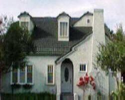
(City of Phoenix 1992). The Ranch style homes of the
1940s to 1950s mirror these demands, as well as the
values of frugal Americans who lived through the Great
Depression.
Between 1945 and 1950, two more
subdivisions were platted in the Brentwood neighborhood
to meet the rising demand for middle-income housing:
Valley of the Sun (1944) and the Governor Hunt Tract
(1946). The Valley of the Sun subdivision is one of the
first that reflected a relatively new strategy for
developers: the platting of a subdivision and building
all of the houses. The Sun Valley Housing Company
authorized the plat and constructed the Ranch style
houses which were largely completed by 1947.
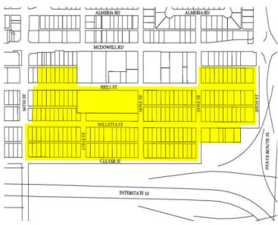
The Brentwood Historic District
The
Brentwood Historic District consists of six original
subdivisions (Table 2). Home construction in the
Brentwood neighborhood reflects pre-Depression, New Deal
and war/post-war expansion and stylistic patterns of
residential development in Phoenix. Between 1926 and
1932, three subdivisions were platted in the district:
McDowell Heights, Brentwood and East Brentwood. With
economic collapse in the Valley in 1932, construction
came to a virtual halt in Phoenix and the Brentwood
neighborhood and the city postponed future subdivisions.
This chaotic period was also characterized by periodic
abandonment of houses in the area. By the late 1930's,
city officials were again promoting additional
expansion, particularly northeast of the central
business district (Kotlanger 1983). The Wright Davis
subdivision was platted in 1938. As Phoenix emerged from
the Great Depression in 1940, the Brentwood neighborhood
was comprised of four well-developed subdivisions and
the pace of housing construction increased dramatically
during the war and the following decade.
Early
households near the future Brentwood Historic District
included Governor Hunt’s mansion at 1679 E. McDowell
Road and Joseph Egly’s date farm at 1925 E. McDowell
Road. Egly’s date farm was one of the largest in the
Valley at the time. These landmarks remained a part of
the growing residential district through the late 1930s.
Although many of Egly’s date palms were destroyed as
house construction progressed, several current
homeowners claim that the date palms in their yards or
along the streets are remnants of the original date
farm.
In July of 1924, McDowell Heights was
subdivided by L.W. and Anna Greer. The subdivision is
bounded by McDowell Road to the north, 16th Street to
the west, 17th Street to the east, and the Brill Street
alley to the south. Because the city limits did not
extend beyond 16th Street to the east or McDowell Road
to the south at this time, the boundaries were marked by
iron pipes. L.W. Greer began development of the
subdivision shortly after platting it. An Arizona
Republican article from Sunday, September 6, 192 touted,
“Contractor and Rancher Building First of 16 Residences
to total $68,000 in Cost on McDowell Road.” The
“Contractor and Rancher” was L.W. Greer who worked in
Phoenix as a plumber. The sixteen units were to range
from five to six rooms and were offered at between
$3,500 and $5,500. Although moderately priced, Greer
marketed the homes as being “modern in every detail,
with many elaborate features not found in the small
home.”
In January and September of 1928, two more
subdivisions were platted in the district: the Brentwood
and East Brentwood subdivisions. The earliest
advertisement for the Brentwood subdivision can be found
in the March 4, 1928 Arizona Republican. Jesse E. Dowell
listed himself as owner and developer and marketed
“Moderately Priced Homes… with City Water, Gas and
Electricity,” and was located between 16th and 18th
Streets, Willetta and Culver Streets. Dowell advertised
an open “English Cottage” model and stated, “The home
now ready for inspection has it. Come out and see for
yourself.” Potential buyers were told they could pick
their own lots upon which Dowell would build
“substantial lasting homes at prices that satisfy.”
These early homes were made of brick with asphalt
shingle roofs.
The April 1, 1928 Arizona Republican stated that two
homes had been completed in the tract and were “valued
at upwards of $4,000.” The article went on to state that
four new homes were to be started that week. While
moderately priced homes, they did include “modern
features” such as hardwood flooring and “built in
conveniences.” The success of Dowell’s development most
likely spurred W.T. Machan to plat East Brentwood, just
east of the initial Brentwood plat spanning 19th to 20th
Streets.
East Brentwood was subdivided by W.T. Machan in
September 1928. Machan also served as principal of
Creighton Elementary School and later the superintendent
of the Creighton School District. The William T. Machan
Elementary School at 2140 E. Virginia Avenue was named
in his honor. Today, the existing subdivision is bounded
by Willetta Street on the north, 19th Street on the
west, 20th Street to the east and the Willetta Street
alley to the south. By 1932, houses were scattered
throughout all three early subdivisions. These three
early subdivisions form the bulk of the historic
district.
The Wright Davis Tract was subdivided
in 1938. The subdivision is bounded by McDowell Road to
the north, 19th Street to the west, 20th Street to the
east and the Brill Street alley to the south.
When the United States entered World War II on December
8, 1941, Phoenix became a major defense training and
supply center. The population continued to increase as
workers arrived looking for employment and soldiers
arriving for deployment. A citywide housing shortage
stimulated the housing industry. Numerous houses were
built in the Brentwood neighborhood during the war,
primarily in the Brentwood and East Brentwood sections.
These houses not only reflected the economy and
population expansion of the time, but also reflected the
shortage of supplies; most of the houses were built in
the less-ornamented and more economical Ranch style
during this time period and the post-war period as well.
The Valley of the Sun Tract was subdivided in 1944
by the Sun Valley Housing Company (Attachment 5). The
subdivision is located along Willetta Street between
19th and 20th Streets. Presumably, the Sun Valley
Housing Company was the building contractor as well, as
they were known as one of the earliest companies that
specialized in complete subdivision planning and
building. This trend, later fully expressed in the
complete building of new “cities” by Del Webb and others
(e.g. Sun City, Arizona), grew out of the war effort and
the need to build as quickly, uniformly and
inexpensively as possible (Luckingham 1989).
The
Governor Hunt Tract, subdivided in 1946 by Virginia
Hunt-Frund, Lena Ellison and Valley National Bank, is
located between McDowell Road and Willetta Street, north
to south and 17th Street to 18th Street, west to east.
In 1916, Governor George W.P. Hunt, Arizona’s first
governor, moved into his home at 1679 E. McDowell Road.
For many years, Governor Hunt and his family lived at
this location, surrounded by isolated farmsteads. Upon
his death in 1934, ownership of the house was passed on
to Mrs. Rose Marley. By 1945, Governor Hunt’s daughter,
Virginia Hunt-Frund, acquired the mansion and
subsequently had the property subdivided as the Governor
Hunt Tract. The house was demolished sometime in 1951
for development of the Miracle Mile Shopping Center and
other commercial enterprises along McDowell Road. The
only significant property located in this subdivision is
a church owned by the Church of God in Christ at 1725 E.
Brill Street. The church was constructed between 1947
and 1949 by the Church of Jesus Christ of Latter-Day
Saints. Between 1949 and 1978, it functioned as the
First Ward of the Phoenix East Stake. In 1978, the
property was acquired by the current owners who use the
property for large church meetings and funerals.
Federal programs initiated through the New Deal,
as well as passage of the G.I. Bill in 1946, triggered a
new era of unprecedented housing construction in the
post-war years. By the end of the war, phoenix was
emerging as one of the largest cities in the southwest.
Construction and improvements in the Brentwood Historic
District reflect this growth; house construction
continued at a steady pace through 1956. The
socio-economic status of Brentwood at the time was best
characterized as middle-income, Anglo families.
According to Brentwood residents, during the late 1940's
and early 1950's, Mormon families moved into the
neighborhood to be closer to the new LDS church (Redfern
2002). Occupations ranged from carpenters, plumbers and
teachers to doctors, ministers and government employees.
The decades following the end of World War II
produced significant and permanent changes in the
Brentwood neighborhood. Former Governor Hunts’ mansion
at 1679 E. McDowell Road was razed for commercial
development; predominantly agricultural lands were
transformed into residential suburbs; construction of
Interstate 10 razed buildings in the East Brentwood
subdivision and construction of State Route 51 removed
blocks of the neighborhood’s eastern boundary. These
highways served to restrict access into the
neighborhood, but Brentwood residents claim these
changes benefited the neighborhood by reducing the
amount of cut-through traffic (Redfern 2002). As a
result of this “isolation” that inhibited large-scale
commercial development, the neighborhood has retained
much of its original early to mid-20th Century
attributes and ambience. Although a more diverse ethnic
mix of middle-income families has replaced the earlier,
primarily Anglo residents, the properties themselves are
little changed due to the efforts of the current
residents to keep the neighborhood intact and the houses
in good repair with minimal modification. Brentwood is a
good example of early to mid-20th Century growth of a
Phoenix neighborhood.
Information, maps and
photographs provided courtesy:
Historic Preservation
Office of the City of Phoenix Neighborhood Services
Department
200 West Washington Street
Phoenix,
Arizona 85003
(602) 261-8699
 |

Laura Boyajian
Mobile: 602.400.0008
HistoricCentralPhoenix@cox.net
HomeSmart, LLC
5225 N. Central Ave. #104
Phoenix, AZ 85012
(602)
400.0008
|